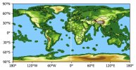
Hi, I downloaded the CESM2 surface altitude data (variable name "orog") from the CMIP6 page https://esgf-node.llnl.gov/search/cmip6/ and when I plot it I get the result shown below, as you can see there is some data surrounding the continents that it is suppose to be ocean so I would like to know if there is a land sea mask file (if possible an .nc file) for this model so I can correct this or if what I got it's how it is suppose to be. Thanks.
CESM2 land-sea mask
- Thread starter mrdo3197
- Start date