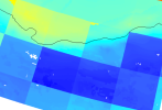
Hi there, I followed the instruction to generate surfdata for a 1km resolution for CLM 5.0, and used the compset: I2000BgcCropGs. However, I found that the output is truly 1km resolution but with big grid, just like a mask on the top, here is the output figure:

It can be seen the output with terrain effect, but with low resolution grid on the top. So, I think this might be caused by the other input datasets, such as forcing data and so on. Here is a list of all input data used in this compset:

... The omitted part includes similar meteorological forcing data.

As I found that the low resolution grid is about 2.5 degree, so I checked all the inputlist and there is only one input data is 2.5 degree, I wonder if we can eliminate this grid effect by replacing this 2.5 degree data.
I look forward to and would appreciate any reply!

It can be seen the output with terrain effect, but with low resolution grid on the top. So, I think this might be caused by the other input datasets, such as forcing data and so on. Here is a list of all input data used in this compset:

... The omitted part includes similar meteorological forcing data.

As I found that the low resolution grid is about 2.5 degree, so I checked all the inputlist and there is only one input data is 2.5 degree, I wonder if we can eliminate this grid effect by replacing this 2.5 degree data.
I look forward to and would appreciate any reply!
