What version of the code are you using?
CESM and E3SM ensembles
Have you made any changes to files in the source tree?
No
Describe every step you took leading up to the problem:
I tried to compare CESM and E3SM data. The E3SM ensemble is ne30 mesh; I need to convert it to FV 0.9x1.25.
My bash job script is below:
#!/bin/bash
module load jaspy
home_path='/gws/nopw/j04/duicv/yuansun/'
drc_in_e3sm=${home_path}dataset/e3sm/inputdata/share/meshes/homme/
drc_in_cesm=${home_path}dataset/inputdata/share/scripgrids/
drc_in_e3sm2=${home_path}dataset/e3sm/mapping/grids/
var=TSA
input_dir=${home_path}dataset/nersc/ccsm/www/E3SMv2/ne30/lnd/proc/tseries/month_1/
output_dir=${home_path}0_ensemble/output_analysis_e3sm/lnd_regrid/fv/month_1/
mapfile=map_ne30pg2_to_fv0.9x1.25_aave.20250329.nc
lnd_iutput_file=v2.LR.SSP370_0111.elm.h0.TSA.201501-210012.nc
lnd_output_flie=test.nc
# create a map file
ncremap -a conserve --grd_src=${drc_in_e3sm}ne30pg2_scrip_c20191218.nc --grd_dst=${drc_in_e3sm2}192x288_SCRIP.20160301.nc --map=${output_dir}/map_ne30pg2_to_fv0.9x1.25_aave.20250329.nc
# convert
ncremap -P elm --var=${var} -m ${output_dir}${mapfile} -i ${input_dir}${lnd_iutput_file} -o ${output_dir}${lnd_output_flie} --sgs_frc=${input_dir}${lnd_iutput_file}/landfrac -R "--rgr col_nm=lndgrid" --sgs_msk=${input_dir}${lnd_iutput_file}/landmask
Describe your problem or question:
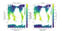
The converted E3SM data has different land grid cells, particularly for coastal areas.
Shall I use a land mask to refine the land grid cells before data analysis? Thanks for any comments.
Best,
Yuan
CESM and E3SM ensembles
Have you made any changes to files in the source tree?
No
Describe every step you took leading up to the problem:
I tried to compare CESM and E3SM data. The E3SM ensemble is ne30 mesh; I need to convert it to FV 0.9x1.25.
My bash job script is below:
#!/bin/bash
module load jaspy
home_path='/gws/nopw/j04/duicv/yuansun/'
drc_in_e3sm=${home_path}dataset/e3sm/inputdata/share/meshes/homme/
drc_in_cesm=${home_path}dataset/inputdata/share/scripgrids/
drc_in_e3sm2=${home_path}dataset/e3sm/mapping/grids/
var=TSA
input_dir=${home_path}dataset/nersc/ccsm/www/E3SMv2/ne30/lnd/proc/tseries/month_1/
output_dir=${home_path}0_ensemble/output_analysis_e3sm/lnd_regrid/fv/month_1/
mapfile=map_ne30pg2_to_fv0.9x1.25_aave.20250329.nc
lnd_iutput_file=v2.LR.SSP370_0111.elm.h0.TSA.201501-210012.nc
lnd_output_flie=test.nc
# create a map file
ncremap -a conserve --grd_src=${drc_in_e3sm}ne30pg2_scrip_c20191218.nc --grd_dst=${drc_in_e3sm2}192x288_SCRIP.20160301.nc --map=${output_dir}/map_ne30pg2_to_fv0.9x1.25_aave.20250329.nc
# convert
ncremap -P elm --var=${var} -m ${output_dir}${mapfile} -i ${input_dir}${lnd_iutput_file} -o ${output_dir}${lnd_output_flie} --sgs_frc=${input_dir}${lnd_iutput_file}/landfrac -R "--rgr col_nm=lndgrid" --sgs_msk=${input_dir}${lnd_iutput_file}/landmask
Describe your problem or question:
The converted E3SM data has different land grid cells, particularly for coastal areas.
Shall I use a land mask to refine the land grid cells before data analysis? Thanks for any comments.
Best,
Yuan