Hi!
I am working with Adam Herrington on analyzing the output of a fully-coupled CESM2 simulation with an interactive Greenland Ice Sheet (CISM activated). The simulation uses the variable-resolution grid ARCTIC, which features ¼˚ regional refinement over the Arctic. There is a former simulation with the same settings except for using the conventional f09 grid. Currently I am comparing the integrated total precipitation over the Greenland Ice Sheet (GrIS) in these two simulations.
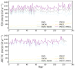
I tried using both the precipitation variables from the land component (RAIN+SNOW) and also from the atmosphere model outputs (PRECC+PRECL). For all these four individual variables, my calculation is the same: GrIS integrated precipitation = sum( precipitation fields * Greenland mask * land fraction * glacier fraction). Then I added either the RAIN and SNOW time series, or the PRECC and PRECL time series together to get the total precipitation. The results are shown in the figure below. The upper subfigure represents results for the f09 grid simulation and the bottom one is for the ARCTIC grid simulation. Since PRECC is really small, the red PRECL line is behind the purple (PRECC+PRECL) line.
I thought, theoretically, the two sums, (RAIN+SNOW) and (PRECC+PRECL), should be the same (of acceptable difference). It is true for the ARCTIC simulation, in which the gray line is behind the purple line. However, for the f09 simulation, the difference of the purple and gray lines is quite large. So far we haven't found a reason for it.
For the f09 simulation, the history files are in /glade/campaign/collections/cmip/CMIP6/timeseries-cmip6/b.e21.B1850G.f09_g17_gl4.CMIP6-1pctCO2to4x-withism.001/ and monthly outputs are used. The Greenland mask is calculated by setting where 'GLACIER_REGION' = 2 in /glade/work/aherring/grids/uniform-res/f09/clm_surfdata_5_0/surfdata_0.9x1.25_hist_78pfts_CMIP5_simyr1850_c200226.nc. to 1 and other grids to 0. Land fraction is achieved from the variable 'landfrac' in any of the clm2.h0 output file. Glacier fraction is index 3 of the variable 'PCT_LANDUNIT' in the clm2.h0 output files (since CISM is activated, the glacier fraction is changing).
So may I ask what could possibly result in this difference? Thanks a lot!
Best,
Ziqi


