Hi all,
I'm trying to run CTSM (ctsm5.2.004) with customized ERA5 forcing and encountered several issues. Any suggestions would be appreciated!
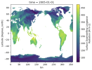
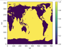
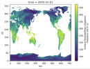
I tested the ERA5 hourly data (bias corrected version) at 0.5x0.5° spatial resolution (Copernicus Climate Data Store | Copernicus Climate Data Store) with DATM_MODE set as GSWP3, and I got the error of Energy conservation error downscaling longwaveERROR and consequently urban net longwave radiation balance error. I checked the original forcing file, and longwave radiation doesn't have any abnormal values. The 0.5x0.5° mesh file (with land mask) I generated also looks normal (please see the figures attached).
I have attached the atm.log, cesm.log, datm.streams.xml used in this case for reference.
I have also tried to compile all the forcing variables into a single file and run CTSM under ERA5 DATM_MODE, and I got the error in NUOPC Invalid argument - Sa_q2m is not a StandardName in the NUOPC_FieldDictionary! However, there is no Sa_q2m in my datm.streams.xml. I have attached the PET0000.ESMF_LogFile as well.
Thanks,
Yifan
I'm trying to run CTSM (ctsm5.2.004) with customized ERA5 forcing and encountered several issues. Any suggestions would be appreciated!
I tested the ERA5 hourly data (bias corrected version) at 0.5x0.5° spatial resolution (Copernicus Climate Data Store | Copernicus Climate Data Store) with DATM_MODE set as GSWP3, and I got the error of Energy conservation error downscaling longwaveERROR and consequently urban net longwave radiation balance error. I checked the original forcing file, and longwave radiation doesn't have any abnormal values. The 0.5x0.5° mesh file (with land mask) I generated also looks normal (please see the figures attached).
I have attached the atm.log, cesm.log, datm.streams.xml used in this case for reference.
I have also tried to compile all the forcing variables into a single file and run CTSM under ERA5 DATM_MODE, and I got the error in NUOPC Invalid argument - Sa_q2m is not a StandardName in the NUOPC_FieldDictionary! However, there is no Sa_q2m in my datm.streams.xml. I have attached the PET0000.ESMF_LogFile as well.
Thanks,
Yifan