Hi there,
I am encountering an issue initializing CLM5 in CESM2.1 using the B1850.f09_g17 compset, but which I have modified to model changes in the Antarctic ice sheet. This required a grid change in the ocean model but the land surface dataset is still 192x288; however, the land mask, soil properties and ice sheet extent south of 60°S have been changed.
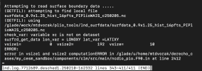
The model reads in GLACIER_REGION, urban input data and PFT physiological data fine, but throws the following error when reading the surface boundary data:

I believe a similar issue was presented here: Customized surfdata does not work , but in my case I am sure that the domain file and the surface dataset match in dimensions. After reading the code in ncdio_pio.F90.in, I am still unsure how vsizes are calculated.
Also, this is a startup run in which CLM5 is initializing from: b.e20.B1850.f09_g17.pi_control.all.299_merge_v3.clm2.r.0134-01-01-00000.nc. I had assumed that the interpolation scheme (INIT_INTERP_METHOD = "use_finidat_areas") would be able to interpolate from this initial dataset to the land surface dataset I've provided, with its customized landmask, but perhaps I need to do this myself and also provide a customized finidat file too?
Thank you for your help.
Michelle
I am encountering an issue initializing CLM5 in CESM2.1 using the B1850.f09_g17 compset, but which I have modified to model changes in the Antarctic ice sheet. This required a grid change in the ocean model but the land surface dataset is still 192x288; however, the land mask, soil properties and ice sheet extent south of 60°S have been changed.
The model reads in GLACIER_REGION, urban input data and PFT physiological data fine, but throws the following error when reading the surface boundary data:

I believe a similar issue was presented here: Customized surfdata does not work , but in my case I am sure that the domain file and the surface dataset match in dimensions. After reading the code in ncdio_pio.F90.in, I am still unsure how vsizes are calculated.
Also, this is a startup run in which CLM5 is initializing from: b.e20.B1850.f09_g17.pi_control.all.299_merge_v3.clm2.r.0134-01-01-00000.nc. I had assumed that the interpolation scheme (INIT_INTERP_METHOD = "use_finidat_areas") would be able to interpolate from this initial dataset to the land surface dataset I've provided, with its customized landmask, but perhaps I need to do this myself and also provide a customized finidat file too?
Thank you for your help.
Michelle
