Scheduled Downtime
On Tuesday 24 October 2023 @ 5pm MT the forums will be in read only mode in preparation for the downtime. On Wednesday 25 October 2023 @ 5am MT, this website will be down for maintenance and expected to return online later in the morning.
Normal Operations
The forums are back online with normal operations. If you notice any issues or errors related to the forums, please reach out to help@ucar.edu

./mkmapdata.sh failed in mapping one file

Status
Not open for further replies.

Ceil

Member
Hi,

I sincerely need your help. Many thanks in advance!
I can successfully remap all files except one file (i.e., /inputdata//lnd/clm2/mappingdata/grids/SCRIPgrid_3minx3min_MODISwcspsea_c151020.nc). I do not know why only this file is failed. I had the errors as follows,

Starting weight generation with these inputs:
Source File:
/cesm2.1.3/my_cesm_sandbox/components/clm/tools/mkmapda
ta/lnd/clm2/mappingdata/grids/SCRIPgrid_3minx3min_MODISwcspsea_c151020.nc
Destination File:
/cesm2.1.3/my_cesm_sandbox/components/clm/tools/mkmapgr
ids/SCRIPgrid_1x1_mq_nomask_c231127.nc
Weight File: map_3x3min_MODIS-wCsp_to_1x1_mq_nomask_aave_da_c231129.nc
Source File is in SCRIP format
Source Grid is a global grid
Source Grid is a logically rectangular grid
Use the center coordinates of the source grid to do the regrid
Destination File is in SCRIP format
Destination Grid is a regional grid
Destination Grid is a logically rectangular grid
Use the center coordinates of the destination grid to do the regrid
Regrid Method: conserve
Pole option: NONE
Ignore unmapped destination points
Output weight file in 64bit offset NetCDF file format
Line Type: greatcircle
Norm Type: dstarea
Extrap. Method: none

ERROR: Problem on processor 4
. Please see the PET*.RegridWeightGen.Log files for a traceback.
Abort(1) on node 4 (rank 4 in comm 496): application called MPI_Abort(comm=0x84000003, 1) - process 4

===================================================================================
= BAD TERMINATION OF ONE OF YOUR APPLICATION PROCESSES
= RANK 0 PID 155499 RUNNING AT b2389
= KILLED BY SIGNAL: 9 (Killed)
===================================================================================
 

oleson

Keith Oleson
CSEG and Liaisons
Staff member
Have you looked in your PET log (as noted by "Please see the PET*.RegridWeightGen.Log files for a traceback.")?
What is the command you are using to run this?
 

Ceil

Member
Have you looked in your PET log (as noted by "Please see the PET*.RegridWeightGen.Log files for a traceback.")?
What is the command you are using to run this?
Thanks for your reply! The following is PET00.RegridWeightGen.Log:
20231129 170300.093 INFO PET00 !!!!!!!!!!!!!!!!!!!!!!!!!!!!!!!!!!!!!!!!!!!!!!!!!!!!!!
20231129 170300.093 INFO PET00 !!! THE ESMF_LOG IS SET TO OUTPUT ALL LOG MESSAGES !!!
20231129 170300.093 INFO PET00 !!! THIS MAY CAUSE SLOWDOWN IN PERFORMANCE !!!
20231129 170300.093 INFO PET00 !!! FOR PRODUCTION RUNS, USE: !!!
20231129 170300.093 INFO PET00 !!! ESMF_LOGKIND_Multi_On_Error !!!
20231129 170300.093 INFO PET00 !!!!!!!!!!!!!!!!!!!!!!!!!!!!!!!!!!!!!!!!!!!!!!!!!!!!!!
20231129 170300.093 INFO PET00 Running with ESMF Version : 8.0.1
20231129 170300.098 INFO PET00 ESMF library build date/time: "Feb 26 2021" "10:04:02"
20231129 170300.098 INFO PET00 ESMF library build location : /cluster/work/users/vegarde/build/ESMF/8.0.1/intel-2020a/esmf-ESMF_8_0_1/
20231129 170300.098 INFO PET00 ESMF_COMM : intelmpi
20231129 170300.099 INFO PET00 ESMF_NETCDF : enabled
20231129 170300.099 INFO PET00 ESMF_PNETCDF : disabled
20231129 170300.099 INFO PET00 ESMF_PIO : enabled
20231129 170300.099 INFO PET00 ESMF_YAMLCPP : enabled
20231129 170300.099 INFO PET00 ESMF_MOAB : enabled

The remaining PET*.RegridWeightGen.Log files have the similar content. I could not get something useful to help run it.
 

oleson

Keith Oleson
CSEG and Liaisons
Staff member
Yep, not much help there.
Again, what is the command you are using to run this?
 

Ceil

Member
Yep, not much help there.
Again, what is the command you are using to run this?
Hi Oleson, I think that there are something wrong in SCRIPgrid_3minx3min_MODISwcspsea_c151020.nc (I downloaded it from https://svn-ccsm-inputdata.cgd.ucar.edu/trunk/inputdata/lnd/clm2/mappingdata/grids/).
So I tried to write the values of variables in SCRIPgrid_3minx3min_MODISwcspsea_c151020.nc to SCRIPgrid_3minx3min_MODISv2_c190503.nc to check, because they have similar data format. I successfully got outputs except when grid_corner_lat is used. Specifically, if I rewrite SCRIPgrid_3minx3min_MODISwcspsea_c151020.nc as follows, I can successfully get outputs:
vi test.py
import netCDF4
datadir = './'
fnm1 = netCDF4.Dataset(datadir + 'SCRIPgrid_3minx3min_MODISwcspsea_c151020.nc.original',mode = 'r')
grid_center_lat = fnm1.variables['grid_center_lat'][:]
grid_center_lon = fnm1.variables['grid_center_lon'][:]
grid_corner_lat1 = fnm1.variables['grid_corner_lat'][:]
grid_corner_lon = fnm1.variables['grid_corner_lon'][:]
grid_dims = fnm1.variables['grid_dims'][:]
grid_imask = fnm1.variables['grid_imask'][:]
fnm2 = netCDF4.Dataset(datadir + 'SCRIPgrid_3minx3min_MODISv2_c190503.nc.1',mode = 'r+')
#--------------------------------
#write out to netcdf
#-------------------------------
fnm2.variables["grid_center_lat"][:] = grid_center_lat
fnm2.variables["grid_center_lon"][:] = grid_center_lon
#fnm2.variables["grid_corner_lat"][:] = grid_corner_lat # probably wrong in the original SCRIPgrid_3minx3min_MODISwcspsea_c151020.nc
fnm2.variables["grid_corner_lon"][:] = grid_corner_lon
fnm2.variables["grid_dims"][:] = grid_dims
fnm2.variables["grid_imask"][:] = grid_imask
fnm2.close()

mv SCRIPgrid_3minx3min_MODISv2_c190503.nc.1 SCRIPgrid_3minx3min_MODISwcspsea_c151020.nc

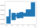
I think that I could not use grid_corner_lat in SCRIPgrid_3minx3min_MODISv2_c190503.nc (i.e., grid_corner_lat2) to replace grid_corner_lat in SCRIPgrid_3minx3min_MODISwcspsea_c151020.nc (i.e., grid_corner_lat1), because their values are not identical. For example, the following picture is their difference (diff = grid_corner_lat1[:,0]-grid_corner_lat2[:,0]):
1701457416627.png

I have no idea how to deal with the situation. Could you check with https://svn-ccsm-inputdata.cgd.ucar.../SCRIPgrid_3minx3min_MODISwcspsea_c151020.nc? If there is really something wrong, could you update the dataset?

The command I am using to run it is: ./mkmapdata.sh -r $GRIDNAME -f $GRIDFILE -t regional
 

Ceil

Member
Yep, not much help there.
Again, what is the command you are using to run this?
Hi Oleson, I also have another two questions, and I feel very confused.

1. My research is about agricultural management, so it seems that the compset FHIST_BGC (I need to open land surface and atmosphere modules) is the best option for me. But this compset is Defined (not Scientific / Tested), probably meaning not so robust. FWHIST_BGC is Scientific / Tested, but my focus is troposphere. I am not sure whether FWHIST_BGC is suitable for me. I am also worried that FWHIST_BGC will be much more time-consuming. Could you recommend a better compset to me if possible?

2. when I run ./mksurfdata.pl -r usrspec -usr_gname $GRIDNAME -usr_gdate $CDATE -l $CSMDATA, this command calls the following dataset:
/inputdata/lnd/clm2/rawdata/pftcftdynharv.0.25x0.25.LUH2.histsimyr0850-1849.c171012/mksrf_landuse_histclm50_LUH2_850.c171012.nc
But I want to use /inputdata/lnd/clm2/rawdata/pftcftdynharv.0.25x0.25.LUH2.histsimyr1850-2015.c170629/mksrf_landuse_histclm50_LUH2_2010.c170629.nc
How can I change the code to repalce the dataset?
I tried to change compset, but it always uses the same dataset. I tried to edit mksurfdata.pl, the following code probably is the key, but I still do not know how to change the code to replace the dataset because I know little about perl:
my $typ_cmd = "$scrdir/../../bld/queryDefaultNamelist.pl $mkopts -options hgrid=$hgrid,lmask=$lmask,mergeGIS=$merge_gis$mkcrop -var $filnm";

What's more, there are multiple datasets for certain variables, such as
mksrf_GlacierRegion_10x10min_nomask_c160122.nc
mksrf_GlacierRegion_10x10min_nomask_c170616.nc
It seems that the only difference is the data creation date. The default called is mksrf_GlacierRegion_10x10min_nomask_c170616.nc, but how can I change the code to use mksrf_GlacierRegion_10x10min_nomask_c160122.nc?
 

slevis

Moderator
Staff member
Hi Oleson, I think that there are something wrong in SCRIPgrid_3minx3min_MODISwcspsea_c151020.nc (I downloaded it from https://svn-ccsm-inputdata.cgd.ucar.edu/trunk/inputdata/lnd/clm2/mappingdata/grids/).
So I tried to write the values of variables in SCRIPgrid_3minx3min_MODISwcspsea_c151020.nc to SCRIPgrid_3minx3min_MODISv2_c190503.nc to check, because they have similar data format. I successfully got outputs except when grid_corner_lat is used. Specifically, if I rewrite SCRIPgrid_3minx3min_MODISwcspsea_c151020.nc as follows, I can successfully get outputs:
vi test.py
import netCDF4
datadir = './'
fnm1 = netCDF4.Dataset(datadir + 'SCRIPgrid_3minx3min_MODISwcspsea_c151020.nc.original',mode = 'r')
grid_center_lat = fnm1.variables['grid_center_lat'][:]
grid_center_lon = fnm1.variables['grid_center_lon'][:]
grid_corner_lat1 = fnm1.variables['grid_corner_lat'][:]
grid_corner_lon = fnm1.variables['grid_corner_lon'][:]
grid_dims = fnm1.variables['grid_dims'][:]
grid_imask = fnm1.variables['grid_imask'][:]
fnm2 = netCDF4.Dataset(datadir + 'SCRIPgrid_3minx3min_MODISv2_c190503.nc.1',mode = 'r+')
#--------------------------------
#write out to netcdf
#-------------------------------
fnm2.variables["grid_center_lat"][:] = grid_center_lat
fnm2.variables["grid_center_lon"][:] = grid_center_lon
#fnm2.variables["grid_corner_lat"][:] = grid_corner_lat # probably wrong in the original SCRIPgrid_3minx3min_MODISwcspsea_c151020.nc
fnm2.variables["grid_corner_lon"][:] = grid_corner_lon
fnm2.variables["grid_dims"][:] = grid_dims
fnm2.variables["grid_imask"][:] = grid_imask
fnm2.close()

mv SCRIPgrid_3minx3min_MODISv2_c190503.nc.1 SCRIPgrid_3minx3min_MODISwcspsea_c151020.nc

I think that I could not use grid_corner_lat in SCRIPgrid_3minx3min_MODISv2_c190503.nc (i.e., grid_corner_lat2) to replace grid_corner_lat in SCRIPgrid_3minx3min_MODISwcspsea_c151020.nc (i.e., grid_corner_lat1), because their values are not identical. For example, the following picture is their difference (diff = grid_corner_lat1[:,0]-grid_corner_lat2[:,0]):
View attachment 4548

I have no idea how to deal with the situation. Could you check with https://svn-ccsm-inputdata.cgd.ucar.../SCRIPgrid_3minx3min_MODISwcspsea_c151020.nc? If there is really something wrong, could you update the dataset?

The command I am using to run it is: ./mkmapdata.sh -r $GRIDNAME -f $GRIDFILE -t regional
The fact that you do not get a helpful error message and that you encounter the problem with 3minx3min makes me suspect that your job may require more memory than available on your machine. I do not know how to help with that type of issue.

Regarding your other questions:
1) I strongly agree that you should not use "whole atmosphere" compsets for the type of work that you're doing. I would not worry about the tested/supported labels. Very few compsets are tested or supported. It just means that you may encounter problems that we do not know about. But this could even happen with a tested/supported compset. So I recommend pursuing your research using the most appropriate compset. Regardless, you will have to conduct testing before running final simulations and publishing papers.
2) This tool reads a namelist that you could change. The README.developers may have hints. In mksurfdata.pl, notice this line:
# Run mksurfdata_map with the namelist file
You have the option of running "mksurfdata_map < namelist" outside the perl script, after changing the namelist.
 

Ceil

Member
The fact that you do not get a helpful error message and that you encounter the problem with 3minx3min makes me suspect that your job may require more memory than available on your machine. I do not know how to help with that type of issue.

Regarding your other questions:
1) I strongly agree that you should not use "whole atmosphere" compsets for the type of work that you're doing. I would not worry about the tested/supported labels. Very few compsets are tested or supported. It just means that you may encounter problems that we do not know about. But this could even happen with a tested/supported compset. So I recommend pursuing your research using the most appropriate compset. Regardless, you will have to conduct testing before running final simulations and publishing papers.
2) This tool reads a namelist that you could change. The README.developers may have hints. In mksurfdata.pl, notice this line:
# Run mksurfdata_map with the namelist file
You have the option of running "mksurfdata_map < namelist" outside the perl script, after changing the namelist.
Hi Slevis, many thanks for your reply and help!
 

Ceil

Member
The fact that you do not get a helpful error message and that you encounter the problem with 3minx3min makes me suspect that your job may require more memory than available on your machine. I do not know how to help with that type of issue.

Regarding your other questions:
1) I strongly agree that you should not use "whole atmosphere" compsets for the type of work that you're doing. I would not worry about the tested/supported labels. Very few compsets are tested or supported. It just means that you may encounter problems that we do not know about. But this could even happen with a tested/supported compset. So I recommend pursuing your research using the most appropriate compset. Regardless, you will have to conduct testing before running final simulations and publishing papers.
2) This tool reads a namelist that you could change. The README.developers may have hints. In mksurfdata.pl, notice this line:
# Run mksurfdata_map with the namelist file
You have the option of running "mksurfdata_map < namelist" outside the perl script, after changing the namelist.

Hi Slevis, I have another question and I have already struggled for it for a long time.
I can run CTSM on a regional scale (such as Europe) after I make regional domain and surface data, but I am not sure whether I can use the similar method to run CESM on a regional scale. Specifically, can I run regional CESM after I make regional domain and surface data (not global)? I know a little about the CESM with variable resolution which has two layers (i.e, one is for global, the other is for the region). But if I do not use the CESM-VR, can I run CESM on a regional model? Sadly speaking, I have tried my best but I could not find a complete example to help me run the CESM on a regional scale.
 

oleson

Keith Oleson
CSEG and Liaisons
Staff member
I see you have posted this to the high resolution forum, that is probably the best case to get an answer about a coupled regional simulation. You might reply to that thread just to update and send out another notification.
 
Status
Not open for further replies.
Top