What version of the code are you using?
CESM2.1.3
Describe your problem or question:
I am currently investigating how the topography data is generated in CESM2 and would like to ask a few specific questions to better understand the process. I would greatly appreciate any clarification or references you could provide.
Thank you very much for your time and support. I would greatly appreciate any insights or documentation you can share regarding these topics.
CESM2.1.3
Describe your problem or question:
I am currently investigating how the topography data is generated in CESM2 and would like to ask a few specific questions to better understand the process. I would greatly appreciate any clarification or references you could provide.
- Source DEM Data
Could you please confirm which digital elevation model (DEM) was used to generate the topography data in CESM2? Was it based on GTOPO30, GMTED2010 (1km or 250m resolution), or another dataset? - Differences in Greenland SGH30 Fields
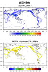
I have been comparing the following two topography files:- fv_1.9x2.5_nc3000_Nsw084_Nrs016_Co120_Fi001_ZR_031819.nc
- fv_1.9x2.5_nc3000_Nsw084_Nrs016_Co120_Fi001_ZR_GRNL_031819.nc
- While the filenames differ only by the inclusion of "GRNL", I noticed that the SGH30 field is significantly elevated over Greenland in the GRNL version.Could you explain the reasoning or methodology behind this modification? Was there a scientific justification or specific criterion applied to enhance subgrid-scale topographic variance (SGH30) over Greenland?
- Topo Tool Configuration (Topo-NCAR_Topo_2_0_2)
When generating topography using the Topo-NCAR_Topo_2_0_2 tool, particularly during the bin_to_cube and cube_to_target steps, could you provide details about the specific options or settings used during these stages?
Thank you very much for your time and support. I would greatly appreciate any insights or documentation you can share regarding these topics.

