Hi all,
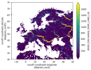
I have been looking into getting streamflow values from MOSART, and was wondering as to the meaning of the variables at hand. From what I have read (partly on this forum), the variable I want would be RIVER_DISCHARGE_OVER_LAND_LIQ. However, I noticed that most grid cells along the coast are missing - to illustrate this, I show here a temporal mean of RIVER_DISCHARGE_OVER_LAND_LIQ for Europe:

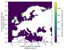
Additionally, I noticed that the variable RIVER_DISCHARGE_TO_OCEAN_LIQ seems to include only the grid cells along the coast (and over the ocean):

Are these variables separated for a particular reason, and if not, can I simply add them up? The TO_OCEAN values are significantly smaller, but not negligible (if you sum them over time and space they are about an order of magnitude smaller), so it seems I can't just ignore these completely.
Would be grateful for any insights on this!
Best regards,
Luna Bloin-Wibe
I have been looking into getting streamflow values from MOSART, and was wondering as to the meaning of the variables at hand. From what I have read (partly on this forum), the variable I want would be RIVER_DISCHARGE_OVER_LAND_LIQ. However, I noticed that most grid cells along the coast are missing - to illustrate this, I show here a temporal mean of RIVER_DISCHARGE_OVER_LAND_LIQ for Europe:

Additionally, I noticed that the variable RIVER_DISCHARGE_TO_OCEAN_LIQ seems to include only the grid cells along the coast (and over the ocean):

Are these variables separated for a particular reason, and if not, can I simply add them up? The TO_OCEAN values are significantly smaller, but not negligible (if you sum them over time and space they are about an order of magnitude smaller), so it seems I can't just ignore these completely.
Would be grateful for any insights on this!
Best regards,
Luna Bloin-Wibe
