Scheduled Downtime
On Tuesday 24 October 2023 @ 5pm MT the forums will be in read only mode in preparation for the downtime. On Wednesday 25 October 2023 @ 5am MT, this website will be down for maintenance and expected to return online later in the morning.
Normal Operations
The forums are back online with normal operations. If you notice any issues or errors related to the forums, please reach out to help@ucar.edu

The surface data produced using the CLM are all 0

Status
Not open for further replies.

weixinyu

weixinyu
Member
Dear all
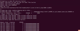
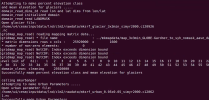
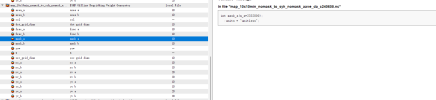
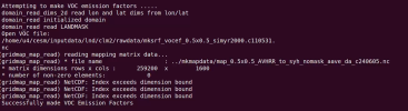
I defined my own resolution and region and successfully followed the process to produce map, domain and surfer data, although the surface data production shows that it has been successful, at the end of the day, when I viewed the surfdata_syh_78pfts_CMIP6_simyr1850_c240617 it showed all zeros, and I put the output logs in a text file.
My procedure is as follows:
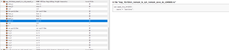
1、Create a new case "syh" with a resolution of 0.1°.
The latitude and longitude of the four points are 101,40, 105,40, 101,37, 105,37
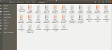
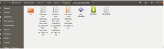
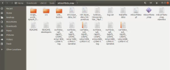
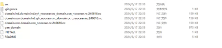
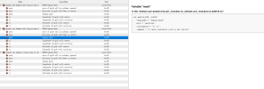
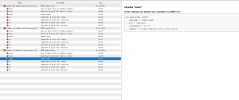
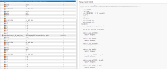
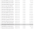
And I successfully created map data, domain data and surfdata,as shown in the figure
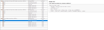
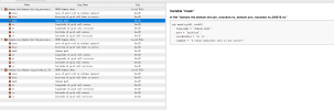
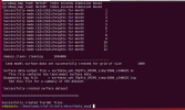
But I don't know why, when I open the last made suferdata, it shows all 0. Please help me with this, thank you very much!
 

Attachments

  • 1718682284971.png
    1718682284971.png
    597.8 KB · Views: 8
  • 1718682311397.png
    1718682311397.png
    684.2 KB · Views: 5
  • 1718720058655.png
    1718720058655.png
    448.6 KB · Views: 4
  • 1718720095428.png
    1718720095428.png
    233.2 KB · Views: 3
  • 1718720112346.png
    1718720112346.png
    374 KB · Views: 5
  • surfdata_syh_78pfts_CMIP6_simyr1850_c240617.txt
    67.3 KB · Views: 3

oleson

Keith Oleson
CSEG and Liaisons
Staff member
I'm not sure we can help with this since we don't have access to the machine you are using, but please attach your surface dataset namelist for 1850. What version of cesm/clm are you using? I guess you should also check the domain file you created to make sure it has land in it.
 

weixinyu

weixinyu
Member
I'm not sure we can help with this since we don't have access to the machine you are using, but please attach your surface dataset namelist for 1850. What version of cesm/clm are you using? I guess you should also check the domain file you created to make sure it has land in it.
Thank you very much for your reply.
I am using CLM version 5.0 and I use the command. /create_newcase --case Hist_syh --res CLM_USRDAT --compset IHistClm50Bgc successfully created Hist_syh,I put the nc data image of my domain in the attachment, please you you check it, thank you very much!
 

Attachments

  • 1718726550731.png
    1718726550731.png
    82.1 KB · Views: 5
  • 1718726591115.png
    1718726591115.png
    83.5 KB · Views: 6

weixinyu

weixinyu
Member
I'm not sure we can help with this since we don't have access to the machine you are using, but please attach your surface dataset namelist for 1850. What version of cesm/clm are you using? I guess you should also check the domain file you created to make sure it has land in it.
Another thing I thought of is that when I created the MAP data, domain data I didn't let him define it as clm version 5.0, I see that the default generated is version 4.5, could this be the reason?
 

oleson

Keith Oleson
CSEG and Liaisons
Staff member
Check the mask variable in your domain.lnd.... file to make sure there is land. Land points should have 1 for the mask.

What is the output of the command "git describe" in your clm5.0 directory?
 

weixinyu

weixinyu
Member
Dear oleson
As you said I checked the domain mask and found that the value is 0. Is there a problem in making my domain file? How should I modify it?
Besides that, the output value of git describe is release-clm5.0.03, how to change it, thanks for your reply!
 

Attachments

  • 1718759498362.png
    1718759498362.png
    80.5 KB · Views: 4
  • 1718759519138.png
    1718759519138.png
    80.7 KB · Views: 4
  • 1718759532075.png
    1718759532075.png
    81.5 KB · Views: 6
  • 1718759549928.png
    1718759549928.png
    48.5 KB · Views: 8

oleson

Keith Oleson
CSEG and Liaisons
Staff member
If your mask in your domain.lnd..... file is all zeros then yes there is a problem in making your domain file. You'll need to look at the process you used to create that file. Maybe your mapping file is incorrect.
 

weixinyu

weixinyu
Member
If your mask in your domain.lnd..... file is all zeros then yes there is a problem in making your domain file. You'll need to look at the process you used to create that file. Maybe your mapping file is incorrect.
Thank you very much for your reply.
How should I see if my mapping file is correct or not?
 

weixinyu

weixinyu
Member
如果您的掩码在 domain.lnd 中.....文件都是零,那么是的,制作域文件有问题。您需要查看用于创建该文件的过程。可能您的映射文件不正确。
我可以麻烦你解释一下吗?因为映射数据很复杂,需要大量的内存,我需要用别人的工作站来做,我用别人的工作站做了测绘数据,然后复制到我自己的电脑上,这有什么效果吗?使用相同的 clm 配置。
您能具体告诉我如何查看映射数据是否正确吗?
谢谢!
 

oleson

Keith Oleson
CSEG and Liaisons
Staff member
I think I would look at the variables mask_a and mask_b in that file. I think mask_a would have all zeros and mask_b would have all ones.
 

weixinyu

weixinyu
Member
Dear oleson
I made a total of 17 mapping data, I opened each one to view it and found that mask_a is not 0 and mask_b is not 1
Can I ask what is the reason for this? I have put my data details in the attachment below, could you please take a look, thank you very much!
 

Attachments

  • 1718896800300.png
    1718896800300.png
    111.1 KB · Views: 6
  • 1718896808184.png
    1718896808184.png
    41.3 KB · Views: 6
  • 1718896815692.png
    1718896815692.png
    41.8 KB · Views: 5
  • 1718896871108.png
    1718896871108.png
    36.8 KB · Views: 6

oleson

Keith Oleson
CSEG and Liaisons
Staff member
I would look at the mapping file that was specified as an argument in the gen_domain step.
 

weixinyu

weixinyu
Member
I would look at the mapping file that was specified as an argument in the gen_domain step.
Dear oleson
I'm very sorry because I'm a beginner in clm, could you please point out specifically what file you're looking at in that place? I didn't understand a bit of what you were saying, thank you very much for your reply!
 

weixinyu

weixinyu
Member
I would look at the mapping file that was specified as an argument in the gen_domain step.
Dear oleson
I looked at mask_a and mask_b in my map file and they were 0 and 1 respectively, other than that I reran it and found that making the mksurfdata_map showed
* number of non-zero elements: 0
(gridmap_map_read) NetCDF: Index exceeds dimension bound

The result of the data generated in this section is 0.
How should this be solved? Could you please answer again?
 

Attachments

  • 1719371724006.png
    1719371724006.png
    426.1 KB · Views: 1
  • 1719371775442.png
    1719371775442.png
    794.1 KB · Views: 1

oleson

Keith Oleson
CSEG and Liaisons
Staff member
Please confine your posts that are related to this subject to a single thread (this one here). It's confusing to have to go back and forth between threads. So far I don't see the cause of the problem. At this point, I ask that you post all of the steps you took from beginning to end that produced the surface dataset with the zeros. Perhaps then we can see the source of the problem or as a last resort try to replicate the process here on our machine.
 
Status
Not open for further replies.
Top