Scheduled Downtime
On Tuesday 24 October 2023 @ 5pm MT the forums will be in read only mode in preparation for the downtime. On Wednesday 25 October 2023 @ 5am MT, this website will be down for maintenance and expected to return online later in the morning.
Normal Operations
The forums are back online with normal operations. If you notice any issues or errors related to the forums, please reach out to help@ucar.edu

transverse stretch stripes in surfdata generated with self made rawdata

Fuhow

Fu Hao
Member
Hi!
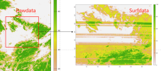
In order to replace the raw data for surfdata, I write some variables as .nc following the steps in cesm2.2.0/component/clm/tools/mksurfdata_map/src/Readme.developers. However, after the surfdata generated, it shows with some transverse stretch stripes in lat direction, as shown below:
1727271545726.png

I used nearly same resolution for raw data and destination grid, all the mksurfdata check process succeeded, and raw data check is OK, but this error occurred. I have no idea about this stripes, it looks like some abnormal conversion coefficients, such as fractions in map_a_to_b.nc?
Really appreciated for any advice!
 

Fuhow

Fu Hao
Member
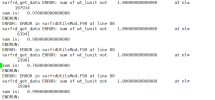
Hi! During the test of writting raw data into surfdata and subimt the case later, I found an error says there are some units' PCT_varis_sum are not equa to 1 in cesm.log, so, is there a possibility of these strips were caused by the stretch of mksurfdata.pl to force PCT_vari_sum to 1? What's more, the const vari such as harvest is not stretched that much.

1728445066078.png
 

oleson

Keith Oleson
CSEG and Liaisons
Staff member
It does seem likely that there is something wrong with your mapping file that is associated with your new raw data. I don't know specifically what could be wrong. If anybody else has any ideas, please chime in.
 

Fuhow

Fu Hao
Member
It does seem likely that there is something wrong with your mapping file that is associated with your new raw data. I don't know specifically what could be wrong. If anybody else has any ideas, please chime in.
Hi, Oleson, Thanks for your response

During generating surfdata by self made rawdata with high resolution (nearly 1km), I truely found the map_trans_from_src_to_dst file had a value around 2 globally while other frac_b for official variable is around 1, of course, this is just one of the things that I found strange, and it may not be the key to the problem.

Then I searched a post by Bill where he suggested that UGRID is more suitable for representing high-resolution data than SCRIPgrid, so I wondered if using UGRID to represent my self-made rawdata would reduce the stretching phenomenon. https://bb.cgd.ucar.edu/cesm/threads/memory-requirement-for-mkmapdata.2186/post-9790
 
Top