Hi, everyone,
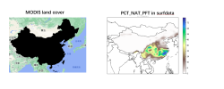
Recenly i have checked the PCT_NAT_PFT in surfdata_0.9x1.25_hist_16pfts_Irrig_CMIP6_simyr2000_c190214.nc (left figure) , the below figure display the
"needleleaf_evergreen_temperate_tree" layer, but when i check the same type in MODIS land cover data (at year of 2001, left figure ), i found they are totally different.
But to my knowledge, there are not some many needleleaf_evergreen_temperate_tree in southern China, so may be the PCT_NAT_PFT in surfacedata is something wrong.
This will cause trouble when I analyse the forest impact on climate.
Do you have any idea of it.

