Dear all,
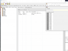
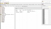
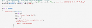
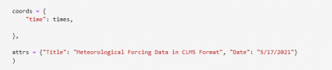
I made my own clm meterological forcing data by python, xarray package. I followed the forcing data "GSWP3v1" format. However, the coordinate "time" in GSWP showed float values and the unit is "days since...". I tried the python fucntion "cftime.num2date()" and set the unit as "days since..." to create the coordinate "time" for my own forcing data. However, the values of "time" are "int" format and the unit is "hours since...". The error "calendar dates must be increasing" showed up in the model when I used my own forcing data running over one month. However, if I run the model less than a month, no error showed up and it looks like it worked fine.
I attached the figures below to show the difference between them. I would like to ask how to create the coordinate "time" to meet the requirement of the clm model. Is there a template I can follow? And how to solve this running problem. THANKS!!!