Scheduled Downtime
On Tuesday 24 October 2023 @ 5pm MT the forums will be in read only mode in preparation for the downtime. On Wednesday 25 October 2023 @ 5am MT, this website will be down for maintenance and expected to return online later in the morning.
Normal Operations
The forums are back online with normal operations. If you notice any issues or errors related to the forums, please reach out to help@ucar.edu

(CLM4.5)Make single-point surface data, the PFT type in the log file is all 0??

xiuyi

xiuyi wu
New Member
Dear all,
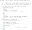
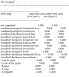
I used CLM4.5 to make single-point surface data. The spatial resolution was 0.1°*0.1°(./mknoocnmap.pl utility default value). No errors were reported during the operation and surface 1850 and 2000 files were successfully generated (surfdata_1x1_CN-Qia_simyr1850_c211028.nc and surfdata_1x1_CN-Qia_simyr2000_c211028.nc). However, I found that the vegetation types in my log file are all 0, whether it is input or output.
1638843014155.png
However, the actual vegetation of the site of interest I selected should be a coniferous forest. I think the vegetation cannot be 0. I'm not sure which step in the production of surface data can be modified. I sincerely hope seniors can give me some guidance or tell me how to judge whether the surface data I have made meets the requirements.
I would be very grateful if I could get your help.

Xiuyi
 

Attachments

  • surfdata_1x1_CN-Qia_simyr1850_c211009.txt
    34.5 KB · Views: 3

oleson

Keith Oleson
CSEG and Liaisons
Staff member
Please describe the steps you took to create the surface dataset so that we can try to replicate the dataset here.

Maybe you've picked a location that only has special landunits. What are the values of PCT_NATVEG, PCT_CROP, PCT_URBAN, PCT_LAKE, PCT_GLACIER, PCT_WETLAND?
 

xiuyi

xiuyi wu
New Member
Please describe the steps you took to create the surface dataset so that we can try to replicate the dataset here.

Maybe you've picked a location that only has special landunits. What are the values of PCT_NATVEG, PCT_CROP, PCT_URBAN, PCT_LAKE, PCT_GLACIER, PCT_WETLAND?
Thanks for your reply!
Above all, let me describe in detail the steps I took to create my surface dataset.The premise is that I have activated or compiled all the relevant tools. I will not repeat the intermediate process, only the process of generating the file.

(1) First, I set the following in the environment variable:(vi .bashrc)
export GRIDNAME=1x1_CN-Qia
export CDATE=`date +%y%m%d`
export GRIDFILE=.../cesm1_2_2/models/lnd/clm/tools/shared/mkmapgrids/SCRIPgrid_${GRIDNAME}_nomask_c${CDATE}.nc
export MAPFILE=.../cesm1_2_2/models/lnd/clm/tools/shared/mkmapdata/map_${GRIDNAME}_noocean_to_${GRIDNAME}_nomask_aave_da_${CDATE}.nc
export OCNDOM=domain.ocn_noocean.nc
export ATMDOM=domain.lnd.${GRIDNAME}_noocean.nc
export CSMDATA=.../cesm_inputdata/lnd/clm2/rawdata/

(2) I started to use mknoocnmap.pl utility to create SCRIP grid file and mapping files. The single point as I understand it is actually a very small area, and a field of 0.1°*0.1° is generated by default.
cd ~/cesm1_2_2/models/lnd/clm/tools/shared/mkmapdata/
./mknoocnmap.pl -p 26.7414, 115.0581 -n $GRIDNAME

(3) makemapdata.sh was used to create mapping files
cd .../cesm1_2_2/models/lnd/clm/tools/shared/mkmapdata
./mkmapdata.sh -r $GRIDNAME -f $GRIDFILE -t regional
Note:This step has a large amount of calculation, so I submitted it to the computing node for calculation in a script file.

#!/bin/csh -f
#set echo on
#PE: set the number of node
#nodes = 3; cpu per node = 24
@ CPUs = 72
./mkmapdata.sh -r $GRIDNAME -f $GRIDFILE -t regional

sbatch makemappingfile

(4) Create domain land file by ./gen_domain
cd .../cesm1_2_2/tools/mapping/gen_domain_files/
./gen_domain -m $MAPFILE -o $OCNDOM -l $ATMDOM
After this step I obtained three domain file:
a.domain.lnd.domain.lnd.1x1_CN-Qia_noocean.nc_domain.ocn_noocean.nc.211011.nc
b.domain.ocn.domain.lnd.1x1_CN-Qia_noocean.nc_domain.ocn_noocean.nc.211011.nc
c.domain.ocn.domain.ocn_noocean.nc.211011.nc

(5)Finally surface data was made.
cd /share/home/lilonghui/lilonghui_liujia/wuxiuyi/cesm1_2_2/models/lnd/clm/tools/clm4_5/mksurfdata_map
./mksurfdata.pl -r usrspec -usr_gname $GRIDNAME -usr_gdate $CDATE > log.out
I got the following relevant surface files:
surfdata_1x1_CN-Qia_simyr1850_c211009.log
surfdata_1x1_CN-Qia_simyr1850_c211009.nc
surfdata_1x1_CN-Qia_simyr2000_c211009.log
surfdata_1x1_CN-Qia_simyr2000_c211009.nc

Note:The following is a screenshot of the surface data I took from the user guidance.
1638927106665.png


The area I am interested in has a latitude of 26.7414 and a longitude of 115.0581. The area around it should be mainly evergreen needleleaf.
And the values of PCT_LAKE, PCT_GLACIER,PCT_WETLAND is all 0, and the value of PCT_NATVEG, PCT_CROP, PCT_URBAN you can seen in my attach files(surface data.zip). There was no error in the process of making surface files, but I just want to know how to check whether the final surface data is consistent with the surface features of my actual area of interest?
I am looking forward to your reply and guidance again.

Xiuyi
 

Attachments

  • surface data.zip
    16 KB · Views: 4

xiuyi

xiuyi wu
New Member
Thanks for your reply!
Above all, let me describe in detail the steps I took to create my surface dataset.The premise is that I have activated or compiled all the relevant tools. I will not repeat the intermediate process, only the process of generating the file.

(1) First, I set the following in the environment variable:(vi .bashrc)
export GRIDNAME=1x1_CN-Qia
export CDATE=`date +%y%m%d`
export GRIDFILE=.../cesm1_2_2/models/lnd/clm/tools/shared/mkmapgrids/SCRIPgrid_${GRIDNAME}_nomask_c${CDATE}.nc
export MAPFILE=.../cesm1_2_2/models/lnd/clm/tools/shared/mkmapdata/map_${GRIDNAME}_noocean_to_${GRIDNAME}_nomask_aave_da_${CDATE}.nc
export OCNDOM=domain.ocn_noocean.nc
export ATMDOM=domain.lnd.${GRIDNAME}_noocean.nc
export CSMDATA=.../cesm_inputdata/lnd/clm2/rawdata/

(2) I started to use mknoocnmap.pl utility to create SCRIP grid file and mapping files. The single point as I understand it is actually a very small area, and a field of 0.1°*0.1° is generated by default.
cd ~/cesm1_2_2/models/lnd/clm/tools/shared/mkmapdata/
./mknoocnmap.pl -p 26.7414, 115.0581 -n $GRIDNAME

(3) makemapdata.sh was used to create mapping files
cd .../cesm1_2_2/models/lnd/clm/tools/shared/mkmapdata
./mkmapdata.sh -r $GRIDNAME -f $GRIDFILE -t regional
Note:This step has a large amount of calculation, so I submitted it to the computing node for calculation in a script file.

#!/bin/csh -f
#set echo on
#PE: set the number of node
#nodes = 3; cpu per node = 24
@ CPUs = 72
./mkmapdata.sh -r $GRIDNAME -f $GRIDFILE -t regional

sbatch makemappingfile

(4) Create domain land file by ./gen_domain
cd .../cesm1_2_2/tools/mapping/gen_domain_files/
./gen_domain -m $MAPFILE -o $OCNDOM -l $ATMDOM
After this step I obtained three domain file:
a.domain.lnd.domain.lnd.1x1_CN-Qia_noocean.nc_domain.ocn_noocean.nc.211011.nc
b.domain.ocn.domain.lnd.1x1_CN-Qia_noocean.nc_domain.ocn_noocean.nc.211011.nc
c.domain.ocn.domain.ocn_noocean.nc.211011.nc

(5)Finally surface data was made.
cd /share/home/lilonghui/lilonghui_liujia/wuxiuyi/cesm1_2_2/models/lnd/clm/tools/clm4_5/mksurfdata_map
./mksurfdata.pl -r usrspec -usr_gname $GRIDNAME -usr_gdate $CDATE > log.out
I got the following relevant surface files:
surfdata_1x1_CN-Qia_simyr1850_c211009.log
surfdata_1x1_CN-Qia_simyr1850_c211009.nc
surfdata_1x1_CN-Qia_simyr2000_c211009.log
surfdata_1x1_CN-Qia_simyr2000_c211009.nc

Note:The following is a screenshot of the surface data I took from the user guidance.
View attachment 1859


The area I am interested in has a latitude of 26.7414 and a longitude of 115.0581. The area around it should be mainly evergreen needleleaf.
And the values of PCT_LAKE, PCT_GLACIER,PCT_WETLAND is all 0, and the value of PCT_NATVEG, PCT_CROP, PCT_URBAN you can seen in my attach files(surface data.zip). There was no error in the process of making surface files, but I just want to know how to check whether the final surface data is consistent with the surface features of my actual area of interest?
I am looking forward to your reply and guidance again.

Xiuyi
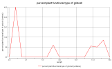
I checked the generated surface data nc file and found that there is a variable name: PCT_PFT. As shown in the figure below, I don’t know if it represents the vegetation type of my single point area. The accumulated percentage is 98.94%. I don’t know where the remaining 1.06% went?
1638934131102.png
 

oleson

Keith Oleson
CSEG and Liaisons
Staff member
Thanks for all of the information. Sorry, I didn't notice you were using CLM4.5 tools in CESM1_2_2 which creates older versions of surface datasets.
Yes, PCT_PFT represents the vegetation types of your area.
The remainder appears to be urban:

PCT_URBAN =
0,
0.111084223698005,
0.944490808614733 ;

So, 0.0% of the tall building district density type, 0.11% for high density, and 0.94% for medium density.
 

xiuyi

xiuyi wu
New Member
Thanks for all of the information. Sorry, I didn't notice you were using CLM4.5 tools in CESM1_2_2 which creates older versions of surface datasets.
Yes, PCT_PFT represents the vegetation types of your area.
The remainder appears to be urban:

PCT_URBAN =
0,
0.111084223698005,
0.944490808614733 ;

So, 0.0% of the tall building district density type, 0.11% for high density, and 0.94% for medium density.
Many thanks for your reply. I understand this question now.
 
Top