Dear all,
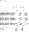
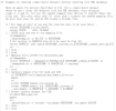
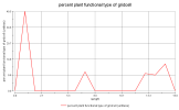
I used CLM4.5 to make single-point surface data. The spatial resolution was 0.1°*0.1°(./mknoocnmap.pl utility default value). No errors were reported during the operation and surface 1850 and 2000 files were successfully generated (surfdata_1x1_CN-Qia_simyr1850_c211028.nc and surfdata_1x1_CN-Qia_simyr2000_c211028.nc). However, I found that the vegetation types in my log file are all 0, whether it is input or output.

However, the actual vegetation of the site of interest I selected should be a coniferous forest. I think the vegetation cannot be 0. I'm not sure which step in the production of surface data can be modified. I sincerely hope seniors can give me some guidance or tell me how to judge whether the surface data I have made meets the requirements.
I would be very grateful if I could get your help.
Xiuyi
I used CLM4.5 to make single-point surface data. The spatial resolution was 0.1°*0.1°(./mknoocnmap.pl utility default value). No errors were reported during the operation and surface 1850 and 2000 files were successfully generated (surfdata_1x1_CN-Qia_simyr1850_c211028.nc and surfdata_1x1_CN-Qia_simyr2000_c211028.nc). However, I found that the vegetation types in my log file are all 0, whether it is input or output.

However, the actual vegetation of the site of interest I selected should be a coniferous forest. I think the vegetation cannot be 0. I'm not sure which step in the production of surface data can be modified. I sincerely hope seniors can give me some guidance or tell me how to judge whether the surface data I have made meets the requirements.
I would be very grateful if I could get your help.
Xiuyi


