hi everyone,
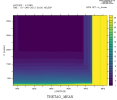
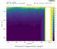
I am running a model for Indian Ocean. For the IC file, I have filled the entire domain(till maximum depth and even land)("ic.png" shows a section along a latitude). The model output does not show bathymetry(output is a column) ("output.png" shows same section). how can i correct this?
(I am running in Z* mode but the problem is there for HYCOM1 too.)