Scheduled Downtime
On Tuesday 24 October 2023 @ 5pm MT the forums will be in read only mode in preparation for the downtime. On Wednesday 25 October 2023 @ 5am MT, this website will be down for maintenance and expected to return online later in the morning.
Normal Operations
The forums are back online with normal operations. If you notice any issues or errors related to the forums, please reach out to help@ucar.edu

How to add a new glacier grid over Tibet Plateau?

peterchu

cwc950106
New Member
Hi,
I want to simulate the mountain glacier evolution over Tibet Plateau using CESM2. So I have made a CISM grid with resolution of 1*1 km ( over the whole Plateau ) and altered the namelist (cism.config) correspondingly. According to the user guide at website "A.1 Introducing a new ice sheet grid — CESM Land Ice CESM2.0 documentation", I have also changed the GLACIER_REGION in CLM surface data and created the files "aave" and "blin" used by the coupler. With the above settings, the model can run with the compset "I1850Clm50SpG". However, the surface mass balance (smb) calculated by CLM always equals to 0 over the entire Tibet Plateau. Does anyone know the reason? ( I have modified the atmospheric forcing data to ensure the temperature is always below freezing point )

Thank you.
 

katec

CSEG and Liaisons
Staff member
Quick question, exactly which version of CESM2 are you using here? CESM2.1?
 

katec

CSEG and Liaisons
Staff member
Also, it is likely that your glacier regions are not set up quite right. Could you please send over your GLACIER_REGION namelist and surface file settings?

This is from the documentation:
If you want ice sheet forcings (SMB and surface temperature) for regions other than the standard Greenland CISM domain, it is critical that you give some thought to this GLACIER_REGION field and the associated namelist options: You will need to ensure that your glacier regions are set up to have virtual elevation classes (glacier_region_behavior = 'virtual'), and that glaciers produce a valid SMB field (glacier_region_melt_behavior = 'replaced_by_ice') wherever you want forcings for CISM.
 

peterchu

cwc950106
New Member
Also, it is likely that your glacier regions are not set up quite right. Could you please send over your GLACIER_REGION namelist and surface file settings?

This is from the documentation:
If you want ice sheet forcings (SMB and surface temperature) for regions other than the standard Greenland CISM domain, it is critical that you give some thought to this GLACIER_REGION field and the associated namelist options: You will need to ensure that your glacier regions are set up to have virtual elevation classes (glacier_region_behavior = 'virtual'), and that glaciers produce a valid SMB field (glacier_region_melt_behavior = 'replaced_by_ice') wherever you want forcings for CISM.
Hi Katec,

Thank you for your reply. I use CESM2 version 2_1_3.
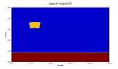
Following figures are glacier behavior settings in lnd_in (whole file can be found in attachments) and glacier_region in surface data.
I have deleted the Greenland glacier region in the origin file and added the whole Tibet Plateau as a new glacier region.
截屏2022-01-25 上午10.00.21.png
截屏2022-01-25 上午10.03.58.png
 

Attachments

  • lnd_in.txt
    6 KB · Views: 1

katec

CSEG and Liaisons
Staff member
Hi there,

So, I can't tell from your picture in the map, but you need your glacier regions to start counting from zero, and the arrays of values in your namelist will correspond to the indexes in the glacier region file. The use of new glacier regions in CESM is somewhat documented, but it is really a very new application that has not been tried very often. If you want to do this, you would be one of the very early adopters of this capability. It would be really great if you could contact Bill Lipscomb at NCAR via email directly to discuss your goals and issues with this project.

With the above information, I tell you how this differs from past applications that have produced SMB. Typically, we keep the Greenland Ice region and add the Himalayan plateau as a new glacier region with an index higher than the other regions. So, if the yellow region above is 4, you should still have regions 1 and 2 on the surface map. I think this might help get SMB to the correct areas.
 
Top