Scheduled Downtime
On Tuesday 24 October 2023 @ 5pm MT the forums will be in read only mode in preparation for the downtime. On Wednesday 25 October 2023 @ 5am MT, this website will be down for maintenance and expected to return online later in the morning.
Normal Operations
The forums are back online with normal operations. If you notice any issues or errors related to the forums, please reach out to help@ucar.edu

ICESM pop restart variable missing

nusbaume

Jesse Nusbaumer
CSEG and Liaisons
Staff member
Hi Xiao,

Yes, you should be able to use the provided iCESM POP2 restart file. If you want to use it directly then you will need to make sure that your ocean grid matches the file (g16). The other option is to just extract the isotope ratio variables and add them to your preferred restart file.

For either case, please note that the model was run for year 1850 boundary conditions, so if you are using a different time period (e.g. year 2000) then there likely will be some spin-up of the ocean isotope values to the non-1850 climate state.

Hope that helps, and have a great day!

Jesse
Thanks very much, Jesse, I will have a try. By the way, say if i want to do a LGM run, how long does it take to get the ocean into an equilibrium state?

Have a nice day :)

Xiao
 

nusbaume

Jesse Nusbaumer
CSEG and Liaisons
Staff member
Hi Xiao,

If you are starting from pre-industrial or modern conditions then it can potentially take a long time, like hundreds or even thousands of ocean model years, until the ocean is spun-up to LGM conditions. Even if the physical ocean is spun-up and you are just trying to spin-up the isotopes it can still take hundreds of model years, depending on where in the ocean you are interested in examining the isotope values.

If you don't have that much computer time, then as an alternative I would probably recommend using the iTRACE data, which is a a fully-coupled iCESM simulation that ran from ~20 kya to 11 kya. It should also contain ocean isotope ratios which you can use to initialize your own simulations, and if you use the starting (20 kya) data it should be much closer to the equilibrated LGM values, and should thus spin-up much more quickly. You can find this iTRACE data on the earth system grid here:

Dataset: iTraCE

And the manuscript describing the iTRACE simulation online here:


Hope that helps, and good luck with your simulations!

Jesse
Thanks very much, Jesse,

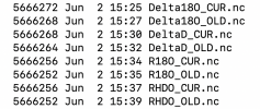
I have unloaded the data and added the following variables (as attached image) to the restart file. I used ncremap to interpolate the data to T31 resolution and the model showed ERROR: incompatible domain grid coordinates. Is it because of the digits of latitudes and longitudes?

e.g. the errors are like:

(seq_domain_check_grid) the domain size is = 251
(seq_domain_check_grid) maximum difference for area 0.130104260698261E-17
(seq_domain_check_grid) maximum allowable difference for area 0.100000001490116

Thanks very much again :)

Xiao
 

Attachments

  • FB982722-4D2D-46D1-84C2-2B346E7A2B5D.png
    FB982722-4D2D-46D1-84C2-2B346E7A2B5D.png
    210.5 KB · Views: 3

nusbaume

Jesse Nusbaumer
CSEG and Liaisons
Staff member
Hi Xiao,

I believe the issue is that POP2 files must be on a tri-pole grid, and thus can't be on a T31 grid. In other words you need to keep the POP2 data on the gXXX grid, unless you are running with prescribed SSTs/sea ice.

Although I know there are various tools out there to re-grid POP2 files, it is sadly outside my area of expertise. Thus I have gone ahead and moved this discussion to the ocean model forum, as someone there will likely be able to tell you what the proper tool/method is for re-gridding POP2 files.

Hope that helps, and have a great day!

Jesse
 
Top