Scheduled Downtime
On Tuesday 24 October 2023 @ 5pm MT the forums will be in read only mode in preparation for the downtime. On Wednesday 25 October 2023 @ 5am MT, this website will be down for maintenance and expected to return online later in the morning.
Normal Operations
The forums are back online with normal operations. If you notice any issues or errors related to the forums, please reach out to help@ucar.edu

Interpreting CLM temperature variables

pesieber

Petra Sieber
New Member
Hello,
I am trying to interpret temperature differences between land cover types (e.g. forest, grass, bare). I have read the theory on the different temperature variables used and calculated in CLM, but I am unsure how to interpret them in the context of vegetation change and climate impacts (e.g. those felt by plants, animals or humans under the canopy bottom, inside the canopy, at the canopy top, over the canopy or nearby a forest).

I looked at the following temperature variables (please correct if any of my "definitions" are wrong):
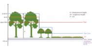
  • TSKIN = radiative temperature; area-weighted mean of TV and TG, both defined from upwelling longwave
  • TAF = canopy air temperature (aka surface temperature); weighted mean of TBOT, TV and TG with conductances for sensible heat
  • TSA = air temperature at 2m height (i.e. 2m above the apparent sink for sensible and latent heat = roughness length (z0) + displacement height (d)); calculated using TAF + Monin-Obukhov similarity theory to relate FSH to the vertical temperature gradient (TAF-TBOT) in neutral/stable/unstable conditions, considering z0)
  • TBOT = air temperature at atmospheric reference height (ZBOT), ca. 16-20m over land; atmospheric forcing variable
I imagine TSKIN indicates the temperature of the ground or vegetation layer, such that it matters e.g. for plant organs themselves (photosynthesis, stomatal conductance) and for animals/humans in direct contact. However, I am unsure how to interpret TAF and TAS as they don't have a precise location in relation to canopy bottom and top.
  • Is TAF necessarily located at a height equal to or below TSA (regardless of land cover)?
  • Is TAF indicative of the temperature inside the canopy, and thus relevant to e.g. animals living in the tree crown?
  • Is TAF used in any CLM calculations of vegetation functioning, or is it mainly an intermediate to calculate FSH and the vertical temperature profile (including TSA)?
  • Is TSA indicative of the temperature closely above the canopy top, and thus relevant nearby plants/animals/humans?
  • Are TSKIN and TAF usually similar (and more similar than TSKIN and TSA), such that either TSKIN or TAF can be interpreted as "surface temperature" and used to calculate FSH? (as I understand it, the usage differs across coupled models and it is sometimes hard to know what was saved as "Ts")
Thanks,
Petra
 

oleson

Keith Oleson
CSEG and Liaisons
Staff member
I think your definitions are generally correct.

In answer to your questions:
1. Yes. TAF is only defined for vegetated canopies and urban canyons. For vegetated canopies, TAF is 2-m below TSA. For urban canopies, TAF is equal to TSA.
2. Yes.
3. TAF is used to calculate fluxes from ground to canopy air, from the vegetation canopy/leaves to the canopy air, and from the canopy air to the atmosphere. See Figure 2.5.1 of the technical note. Here, Ts is TAF. So I would regard it as an intermediate variable.


4. TSA should be at a height of 2m + z0 + d. The z0 and d are calculated as a function of canopy top height and dependent on the pft. See Table 2.5.1:


For tall canopies, I would expect TSA to be within the canopy. However, for short vegetation, I suppose TSA could be slightly above the canopy, haven't checked that before.

5. I believe that in models without an explicit vegetation canopy, there is one "surface temperature" that is calculated that can then be used to calculate FSH. In models with a vegetation canopy like CLM, I think it is typical to use TAF to calculate fluxes. I think TSKIN was added to CLM to perhaps provide a surface temperature that might be compared to, e.g., satellite derived skin temperature.
 

pesieber

Petra Sieber
New Member
Hi Keith, thank you for your answer. I have some follow-up questions on points 4 and 5:

Do the calculations of TAF and TSA consider canopy bottom and top heights in a specific patch, such that it matters if TAF is located under or within the canopy, and TSA within or above the canopy? For instance, does the model consider differences in turbulence under, within and above the canopy? If not (i.e. if the turbulence parameterization is identical under/within/above the canopy and only the vertical wind profile matters), the distinction I was trying might not make sense. I would then just understand TAF as surface air temperature, and TSA as near-surface air temperature.

Are TSKIN and TAF generally similar for all land cover types? e.g. does a grass patch with TSKIN =10° have TAF~10°, and is that the same for forest, such that the temperature difference between grass and forest is not dependent on the choice of TSKIN or TAF? I suppose TSKIN is more variable on short (30min) timescales, so the difference could be larger for daily min/max than mean. However, TAF and its inertia might be more relevant for thermal comfort. If that is right, I wonder why TAF is not a standard output variable of CLM.
 

oleson

Keith Oleson
CSEG and Liaisons
Staff member
The canopy is single-layer, so the turbulence parameterization is the same regardless of location within the canopy. There is a separate parameterization for the ground to canopy air turbulence.
I would think that on a diurnal time scale, TSKIN and TAF could be significantly different. Easiest thing would be to run the model and plot out the results. Whether the model is representative of real-world conditions is another matter. TSA (2-m air temperature) is a standard output from land surface models and it is simply interpolated between TBOT and TAF, so perhaps it was decided that there was no need to output TAF by default. It can easily be turned on however.
 

Gabriel.Hes

Hes
Member
Hi Keith and Petra,
Thank you for this thread which is very helpful. I'm also trying to understand what the different temperatures calculated in CL5 mean. To try to recap the discussion here, I made a little figure (see below). Do you think that this representation is correct?
If I understand correctly, in a forest, none of TAF, TSA or TBOT actually correspond to the temperature at 1-2m above ground. Is there a variable in CLM that would represent this "near surface temperature" that can be measured?
Thanks
Gabriel
 

Attachments

  • Temperature_representation_vegetation_CLM.png
    Temperature_representation_vegetation_CLM.png
    223 KB · Views: 27

strandwg

Moderator
Staff member
Hi Keith and Petra,
Thank you for this thread which is very helpful. I'm also trying to understand what the different temperatures calculated in CL5 mean. To try to recap the discussion here, I made a little figure (see below). Do you think that this representation is correct?
If I understand correctly, in a forest, none of TAF, TSA or TBOT actually correspond to the temperature at 1-2m above ground. Is there a variable in CLM that would represent this "near surface temperature" that can be measured?
Thanks
Gabriel

Jumping in a little bit - the CLM field "TSA" is 2 meter air temperature, so that's the field you want for near surface temperature.
 

Gabriel.Hes

Hes
Member
Jumping in a little bit - the CLM field "TSA" is 2 meter air temperature, so that's the field you want for near surface temperature.
Thank you Strandwg. As I understand it, TSA is the temperature 2m above the roughness length (z0) + displacement height (d)) which means that for forests it is probably diagnosed much higher than 2m above ground level. I am looking for a temperature variable that would be representative of the temperature at this specific height (2m) not depending on the pft.
 

pesieber

Petra Sieber
New Member
Hi Gabriel,
thanks for your addition to the thread and the illustrative figure! I understand it the same way.

Regarding comparability to measurements, I would look for a near-surface air temperature variable diagnosed at e.g. 2m above the canopy top height (H) or 2*H rather than a fixed height above the surface. I think EC measurements over grassland are usually at 2m above the ground (because the grass is max 20 cm high) but over forests they can be at e.g. 35m for a forest with H=18 (where the tallest trees are 35m high). So the challenge would be to define a CLM variable that works for all PFTs and heights.
Since you mentioned 2m above the ground - are you working with measurements at 2m height even in forests?

I was also wondering if the sonic temperature from EC measurements (i.e. the temperature used to calculate the sensible heat flux) is comparable with TAF.
 

Gabriel.Hes

Hes
Member
Hi Gabriel,
thanks for your addition to the thread and the illustrative figure! I understand it the same way.

Regarding comparability to measurements, I would look for a near-surface air temperature variable diagnosed at e.g. 2m above the canopy top height (H) or 2*H rather than a fixed height above the surface. I think EC measurements over grassland are usually at 2m above the ground (because the grass is max 20 cm high) but over forests they can be at e.g. 35m for a forest with H=18 (where the tallest trees are 35m high). So the challenge would be to define a CLM variable that works for all PFTs and heights.
Since you mentioned 2m above the ground - are you working with measurements at 2m height even in forests?

I was also wondering if the sonic temperature from EC measurements (i.e. the temperature used to calculate the sensible heat flux) is comparable with TAF.
Dear Petra,
I don't have any experience working with EC measurements but of what I read it seems like temperature derived from EC measurment would lie somewhere between TAF and TSA?
I am using soil and 1-2m air temperature measurements in forests from De Lombarde et al 2022 (Maintaining forest cover to enhance temperature buffering under future climate change) available here: Global buffering of temperatures under forest canopies: Data and Code
 

pesieber

Petra Sieber
New Member
Dear Gabriel,
I think for EC towers the air temperature sensor can be placed at different heights: usually 2m above ground for grass (so that would be between TAF and TSA, very close to TSA) and often at 2*H for forests (so that would be much higher than TSA). Some forest stations have air temperature sensors at different heights to provide a profile (e.g. 2m, 6m, 9m, etc.).

The dataset looks interesting! I think there is no 1-2m temperature variable in CLM (see full list: 1.2.5. CTSM History Fields — ctsm release-clm5.0 documentation). Maybe it would be fine to interpolate between TAF and TG (i.e. similar to the methods for generating TSA by interpolating between TAF and TBOT).

Cheers,
Petra
 
Top