Dear Scientist,
Recently I want to run a regional case (centerpoint is 114.1°E,30.4°N,grid number is 10×10, and the grid resolution is 0.1°×0.1° ) using CRUNCEP as forcing data and Jackson as surface datasets. However, there are two questions bothering me:
1. The correct step is using ./mknoocnmap.pl to create scripgrid file ,then using mkmapdata.sh to create mapping file, then using gen_domain to create domain file, finally using mksurfdata.pl to create surface data. Am I right?
2. when using mkmapdata.sh, something wrong occurs.
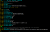
First,
> cd ~/majun/clm5.0/tools/mkmapdata
> ./mknoocnmap.pl -p 114.1,30.4 -n testwuhan -dx 10 -dy 10
It succeed and produce SCRIP file "map_testwuhan_noocean_to_testwuhan_nomask_aave_da_200327.nc"
Then,
> ./mkmapdata.sh -f map_testwuhan_noocean_to_testwuhan_nomask_aave_da_200327.nc -r 10×10 -t regional
error occurs, it shows:
Script to create mapping files required by mksurfdata_map
query command is ./../../bld/queryDefaultNamelist.pl -silent -namelist clmexp -justvalue -options sim_year=2000 -csmdata /home/shenhf/majun/inputdata
Using user specified scrip grid file: map_wuhantest_noocean_to_wuhantest_nomask_aave_da_200327.nc
Output grid resolution is 10×10
Hostname = centos6
Machine centos6 NOT recognized
Creating mapping file: map_0.5x0.5_AVHRR_to_10×10_nomask_aave_da_c200327.nc
From input grid: /home/shenhf/majun/inputdata/lnd/clm2/mappingdata/grids/SCRIPgrid_0.5x0.5_AVHRR_c110228.nc
For output grid: map_wuhantest_noocean_to_wuhantest_nomask_aave_da_200327.nc
WARNING: deprecated switch -src_type will be ignored. The file type will be detected automatically
WARNING: deprecated switch -dst_type will be ignored. The file type will be detected automatically
ERROR: Unable to detect the source grid file type.
Error status returned from mkmapdata script
I want to know what's the problem, is the problem of inputdata? my inpudata path is export CSMDATA=/home/shenhf/majun/inputdata, what should I do to create surface data successfully? any help or suggestion is highly appreciated.
Recently I want to run a regional case (centerpoint is 114.1°E,30.4°N,grid number is 10×10, and the grid resolution is 0.1°×0.1° ) using CRUNCEP as forcing data and Jackson as surface datasets. However, there are two questions bothering me:
1. The correct step is using ./mknoocnmap.pl to create scripgrid file ,then using mkmapdata.sh to create mapping file, then using gen_domain to create domain file, finally using mksurfdata.pl to create surface data. Am I right?
2. when using mkmapdata.sh, something wrong occurs.
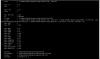
First,
> cd ~/majun/clm5.0/tools/mkmapdata
> ./mknoocnmap.pl -p 114.1,30.4 -n testwuhan -dx 10 -dy 10
It succeed and produce SCRIP file "map_testwuhan_noocean_to_testwuhan_nomask_aave_da_200327.nc"
Then,
> ./mkmapdata.sh -f map_testwuhan_noocean_to_testwuhan_nomask_aave_da_200327.nc -r 10×10 -t regional
error occurs, it shows:
Script to create mapping files required by mksurfdata_map
query command is ./../../bld/queryDefaultNamelist.pl -silent -namelist clmexp -justvalue -options sim_year=2000 -csmdata /home/shenhf/majun/inputdata
Using user specified scrip grid file: map_wuhantest_noocean_to_wuhantest_nomask_aave_da_200327.nc
Output grid resolution is 10×10
Hostname = centos6
Machine centos6 NOT recognized
Creating mapping file: map_0.5x0.5_AVHRR_to_10×10_nomask_aave_da_c200327.nc
From input grid: /home/shenhf/majun/inputdata/lnd/clm2/mappingdata/grids/SCRIPgrid_0.5x0.5_AVHRR_c110228.nc
For output grid: map_wuhantest_noocean_to_wuhantest_nomask_aave_da_200327.nc
WARNING: deprecated switch -src_type will be ignored. The file type will be detected automatically
WARNING: deprecated switch -dst_type will be ignored. The file type will be detected automatically
ERROR: Unable to detect the source grid file type.
Error status returned from mkmapdata script
I want to know what's the problem, is the problem of inputdata? my inpudata path is export CSMDATA=/home/shenhf/majun/inputdata, what should I do to create surface data successfully? any help or suggestion is highly appreciated.