We are running simulations (f-compset) with water tracking in CESM2-geotrace on a regionally refined grid over South America. We are using CAM5 physics to reduce model cost, but all other components are consistent with CESM2 (/glade/work/marcusl/CESM_model_versions/cesm2.2.0.geotrace). The grid has the standard nominal 1-degree ne30pg3 global resolution, with a 0.25-degree refinement over the broader South American continent.
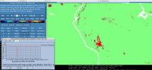
We have encountered some unusual behavior in a few grid cells near the Andes, where the tracked PRECL (and tracked PRECT) and TMQ occasionally show negative values. These negative values do not appear consistently, and not all tracked boxes show them. However, when they do occur, they are several orders of magnitude larger than those in neighboring grid cells. The attached screenshot highlights the issue for tracked PRECT at a daily frequency. The red blob represents PRECT from a storm near the Andes, and within it, one pixel (blue pixel) shows a large negative value. This issue also appears in the monthly mean and is present in several monthly files from multiple tracked regions. The line plot in the lower left corner shows the time series for the blue pixel — the negative value is 2-3 orders of magnitude greater than any positive values in this grid cell. All untracked/default fields (including PRECL, PRECT, and TMQ) appear fine.
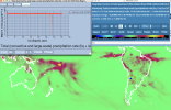
We also examined the raw output files on the unstructured grid to rule out issues with interpolation to a lat-lon grid, and the problem persists in those files as well. We have carefully reviewed all surface boundary conditions to rule out issues with lakes, wetlands, vegetation, topography, sub-grid topography, etc.
Has anyone experienced something similar or have any suggestions on what might be causing this and how we can address it? Any ideas are appreciated.
We have encountered some unusual behavior in a few grid cells near the Andes, where the tracked PRECL (and tracked PRECT) and TMQ occasionally show negative values. These negative values do not appear consistently, and not all tracked boxes show them. However, when they do occur, they are several orders of magnitude larger than those in neighboring grid cells. The attached screenshot highlights the issue for tracked PRECT at a daily frequency. The red blob represents PRECT from a storm near the Andes, and within it, one pixel (blue pixel) shows a large negative value. This issue also appears in the monthly mean and is present in several monthly files from multiple tracked regions. The line plot in the lower left corner shows the time series for the blue pixel — the negative value is 2-3 orders of magnitude greater than any positive values in this grid cell. All untracked/default fields (including PRECL, PRECT, and TMQ) appear fine.
We also examined the raw output files on the unstructured grid to rule out issues with interpolation to a lat-lon grid, and the problem persists in those files as well. We have carefully reviewed all surface boundary conditions to rule out issues with lakes, wetlands, vegetation, topography, sub-grid topography, etc.
Has anyone experienced something similar or have any suggestions on what might be causing this and how we can address it? Any ideas are appreciated.