I am trying to regrid CESM2 ocean output from the native gx1v7 (384×320) grid to the standard regular r1x1 (180×360) grid.
For comparison with the official NCAR products, I used the following two files as a test case:
ncremap -v tos --alg_typ=conserve \
-d tos_Omon_CESM2_omip2_r1i1p1f1_gr_024501-030512.nc \
-i tos_Omon_CESM2_omip2_r1i1p1f1_gn_024501-030512.nc \
-o tos_regridded_180x360.nc
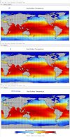
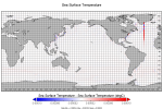
I then compared my regridded result with the official NCAR “gr” file. While the large-scale patterns are very similar, I found noticeable differences near coastlines, where the official gr product appears to be much better behaved (see attached figure).
Therefore, I would like to ask:
- Revision 70792: /trunk/ncl
contains several pre-generated regridding weight files, but I could not find a conservative mapping file for gx1v7 → r1x1 (it has gx1v6 → r1x1 using bilinear remapping).
Overall, I have not yet been able to reproduce the quality of the official CMIP6 gn → gr product, which is remarkably good, especially in marginal seas and coastal regions.
Any guidance or pointers would be greatly appreciated.
For comparison with the official NCAR products, I used the following two files as a test case:
- tos_Omon_CESM2_omip2_r1i1p1f1_gn_024501-030512.nc
- tos_Omon_CESM2_omip2_r1i1p1f1_gr_024501-030512.nc
ncremap -v tos --alg_typ=conserve \
-d tos_Omon_CESM2_omip2_r1i1p1f1_gr_024501-030512.nc \
-i tos_Omon_CESM2_omip2_r1i1p1f1_gn_024501-030512.nc \
-o tos_regridded_180x360.nc
I then compared my regridded result with the official NCAR “gr” file. While the large-scale patterns are very similar, I found noticeable differences near coastlines, where the official gr product appears to be much better behaved (see attached figure).
Therefore, I would like to ask:
- What exact procedure and tools were used at NCAR to convert CESM2 ocean output from gx1v7 (gn) to r1x1 (gr) for OMIP2?
- Were pre-generated mapping/weight files used for this conversion?
(This question was raised in a previous thread but does not seem to have received a definitive answer; see posts #11–14 in:
CESM raw output variable corresponding to cland) - If possible, would it be feasible to share the official gx1v7 → r1x1 conservative remapping weight file used in production?
- Revision 70792: /trunk/ncl
contains several pre-generated regridding weight files, but I could not find a conservative mapping file for gx1v7 → r1x1 (it has gx1v6 → r1x1 using bilinear remapping).
Overall, I have not yet been able to reproduce the quality of the official CMIP6 gn → gr product, which is remarkably good, especially in marginal seas and coastal regions.
Any guidance or pointers would be greatly appreciated.