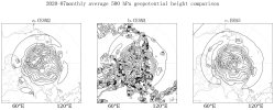
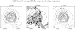
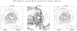
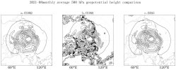
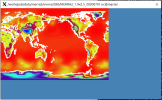
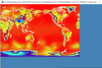
Why is the 500 hPa geopotential height in the CAM5 simulation results so strange over land? The simulation of geopotential height in CAM6 is closer to ERA5, but due to the bias in CAM6's precipitation results, we have to use CAM5 for the study for now. The geopotential height variable (Z3) in both versions of CAM has been processed using the interp_hybrid_to_pressure function from the Python external library geocat-comp before plotting, and the meteorological input data for both is from MERRA2 (with CAM5 at 1.9x2.5 resolution and CAM6 at 0.9x1.25 resolution).
-
The www2.cesm.ucar.edu website is currently down for maintenance
You are using an out of date browser. It may not display this or other websites correctly.
You should upgrade or use an alternative browser.
You should upgrade or use an alternative browser.
Why is the 500 hPa geopotential height in the CAM5 simulation results so strange over land?
I suspect that this is an issue with the interpolation as opposed to the actual model output. I don't think CAM5 and CAM6 should look so different and I don't see a reason why CAM5 should have this weirdness over land. Have you compared the CAM5 and CAM6 inputs to the interpolation function (Z3, PS) to make sure they look similar to one another? When you say you're using MERRA2 as the meteorological input, I'm not sure what you mean by that. Why do you need other meteorological input? You should just be able to use CAM's Z3 and PS as well as the hybrid coefficients to do the interpolation.
I mean I used MERRA2 data as offline meteorology data when running offline CAM5 and 6 and I just can't believe there are so many differences. By the way, I directly compared variable Z500 and the result of CAM5 is still weird on land. I am suspecting there isI suspect that this is an issue with the interpolation as opposed to the actual model output. I don't think CAM5 and CAM6 should look so different and I don't see a reason why CAM5 should have this weirdness over land. Have you compared the CAM5 and CAM6 inputs to the interpolation function (Z3, PS) to make sure they look similar to one another? When you say you're using MERRA2 as the meteorological input, I'm not sure what you mean by that. Why do you need other meteorological input? You should just be able to use CAM's Z3 and PS as well as the hybrid coefficients to do the interpolation.
something wrong with the CAM5 settings.
I compared surface pressure (PS) between MERRA2 at 1.9x2.5 resolution and 0.9x1.25 resolution and found that there was just a little difference between the two.Did you compare the surface pressure inputs too? Perhaps this is particular to the specified dynamics case, but I'm not sure why that would be.
Attachments
But the surface pressure from CAM is also relevant if that's what you're using to do the vertical interpolation. If the model is actually doing something weird you should see it in what you're inputting to the vertical interpolation which would either be PS, Z3 or the hybrid coefficients.